Ingå
You can help expand this article with text translated from the corresponding article in Finnish. (May 2009) Click [show] for important translation instructions.
|
You can help expand this article with text translated from the corresponding article in Swedish. (September 2023) Click [show] for important translation instructions.
|
Ingå
Ingå – Inkoo | |
|---|---|
Municipality | |
| Ingå kommun Inkoon kunta | |
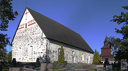
 Ingå Church | |
 Location of Ingå in Finland | |
| Coordinates: 60°02′44″N 24°00′17″E / 60.04556°N 24.00472°E | |
| Country | |
| Region | Uusimaa |
| Sub-region | Raseborg |
| First documents | 1335 |
| Government | |
| • Municipal manager | Jarl Boström |
| Area (2018-01-01)[1] | |
• Total | 954.02 km2 (368.35 sq mi) |
| • Land | 350.85 km2 (135.46 sq mi) |
| • Water | 604.21 km2 (233.29 sq mi) |
| • Rank | 220th largest in Finland |
| Population (2024-10-31)[2] | |
• Total | 5,407 |
| • Rank | 161st largest in Finland |
| • Density | 15.41/km2 (39.9/sq mi) |
| Population by native language | |
| • Swedish | 51.6% (official) |
| • Finnish | 43.3% (official) |
| • Others | 5.2% |
| Population by age | |
| • 0 to 14 | 15.1% |
| • 15 to 64 | 59.2% |
| • 65 or older | 25.8% |
| Time zone | UTC+02:00 (EET) |
| • Summer (DST) | UTC+03:00 (EEST) |
| Climate | Dfb |
| Website | www |
Ingå (Swedish pronunciation: [ˈiŋːo]; Finnish: Inkoo, Finnish: [ˈiŋkoː]) is a municipality in Finland, located in the southern coast of the country. Ingå is situated in the western part of the Uusimaa region. The population of Ingå is approximately 5,000, while the sub-region has a population of approximately 40,000. It is the 161st most populous municipality in Finland.
Ingå is located 37 kilometres (23 mi) east of Ekenäs, the town centre of Raseborg. Ingå covers an area of 954.02 square kilometres (368.35 sq mi) of which 604.21 km2 (233.29 sq mi) is water.[1] The population density is 15.41 inhabitants per square kilometre (39.9/sq mi).
Ingå is a bilingual municipality with Finnish and Swedish as its official languages. The population consists of 43% Finnish speakers, 52% Swedish speakers, and 5% speakers of other languages.
Finnish national road 51 goes right through the southern part of Ingå. The centre consists mainly of the road Bollstavägen that cuts through the Ingå centrum. Along the road are most of the major buildings and shops of the small municipality. A few grocery stores, small kiosk, library and a bar. Towards the Road 51 there is the residential area. Near road 51, at the northern tip of the residential area is the Ingå Volunteer Rescue Company. Nearby villages include Kusans.
Politics
[edit]Results of the 2011 Finnish parliamentary election in Ingå:
- Swedish People's Party 41.5%
- National Coalition Party 20.3%
- Social Democratic Party 16.8%
- Finns Party 9.0%
- Green League 5.4%
- Left Alliance 2.4%
- Centre Party 1.8%
- Christian Democrats 1.5%
See also
[edit]- Degerby
- Karis
- Siuntio
- Inkoo virus (INKV) subtype of California encephalitis orthobunyavirus is named after the Finnish name for the area
References
[edit]- ^ a b "Area of Finnish Municipalities 1.1.2018" (PDF). National Land Survey of Finland. Retrieved 30 January 2018.
- ^ "Finland's preliminary population figure was 5,635,560 at the end of October 2024". Population structure. Statistics Finland. 2024-11-19. ISSN 1797-5395. Retrieved 2024-11-22.
- ^ "Population growth biggest in nearly 70 years". Population structure. Statistics Finland. 2024-04-26. ISSN 1797-5395. Retrieved 2024-04-29.
- ^ "Population according to age (1-year) and sex by area and the regional division of each statistical reference year, 2003–2020". StatFin. Statistics Finland. Retrieved 2 May 2021.
- ^ a b "Luettelo kuntien ja seurakuntien tuloveroprosenteista vuonna 2023". Tax Administration of Finland. 14 November 2022. Retrieved 7 May 2023.
External links
[edit] Media related to Ingå at Wikimedia Commons
 Ingå travel guide from Wikivoyage
- Municipality of Ingå – Official website (in Swedish and Finnish)
- The Cannons at Torp Museum


